Current conditions (weather, water releases, fire risk, closures) to check before you go — see the state of the Verdon.
Current conditions unavailable offline — checking them is mandatory before you set out. Last synchronised: 22 August 2026.
Verified · cross-checked sources
The truth about the numbers
No source agrees on these figures. Rather than silently picking one, we show the value we kept, where it comes from, and why we chose it — the other published values stay visible. We don’t erase contradictions, we explain them.
DistanceCross-checked
10.49 km
Cross-checked against 4 published sources
Value kept after cross-checking the sources. The other values come from GPS tracks or from route variants.
Also published
9.85 km · visorando.com (Belvedere de Plein Voir, 756 m D+, 5h)
10.6 km · komoot.com (700 m D+, 4h32)
7.9 km · lesdeuxpetitsbaroudeurs.com (620 m D+, 4h, depuis parking de Felines)
Verified on 22 August 2026
The Col de l’Âne and Plein Voir loop is a difficult hike that climbs onto the heights of Moustiers-Sainte-Marie, above the faience village, to reach the ridges that dominate the west of the massif. Its reward: plunging views over Lake Sainte-Croix and over the entrance to the Gorges du Verdon. Here is what the sources document precisely — and what they don’t agree on.
Verified on 22 August 2026 with moustiers.fr, the Tourisme Alpes-Haute-Provence portal, Altituderando and AllTrails; supplemented by Villa O Verdon, the CEN PACA and the Parc naturel régional du Verdon for the points added (Saint-Maurin, arch, exposed passages).
The essentials
Distance
10.49 km
Elevation gain
820 m
Duration
4 h to 5 h 20 min depending on the variant
Difficulty
Difficult
Type
Loop
Start
Félines car park (road from Moustiers toward La Palud-sur-Verdon)
High point
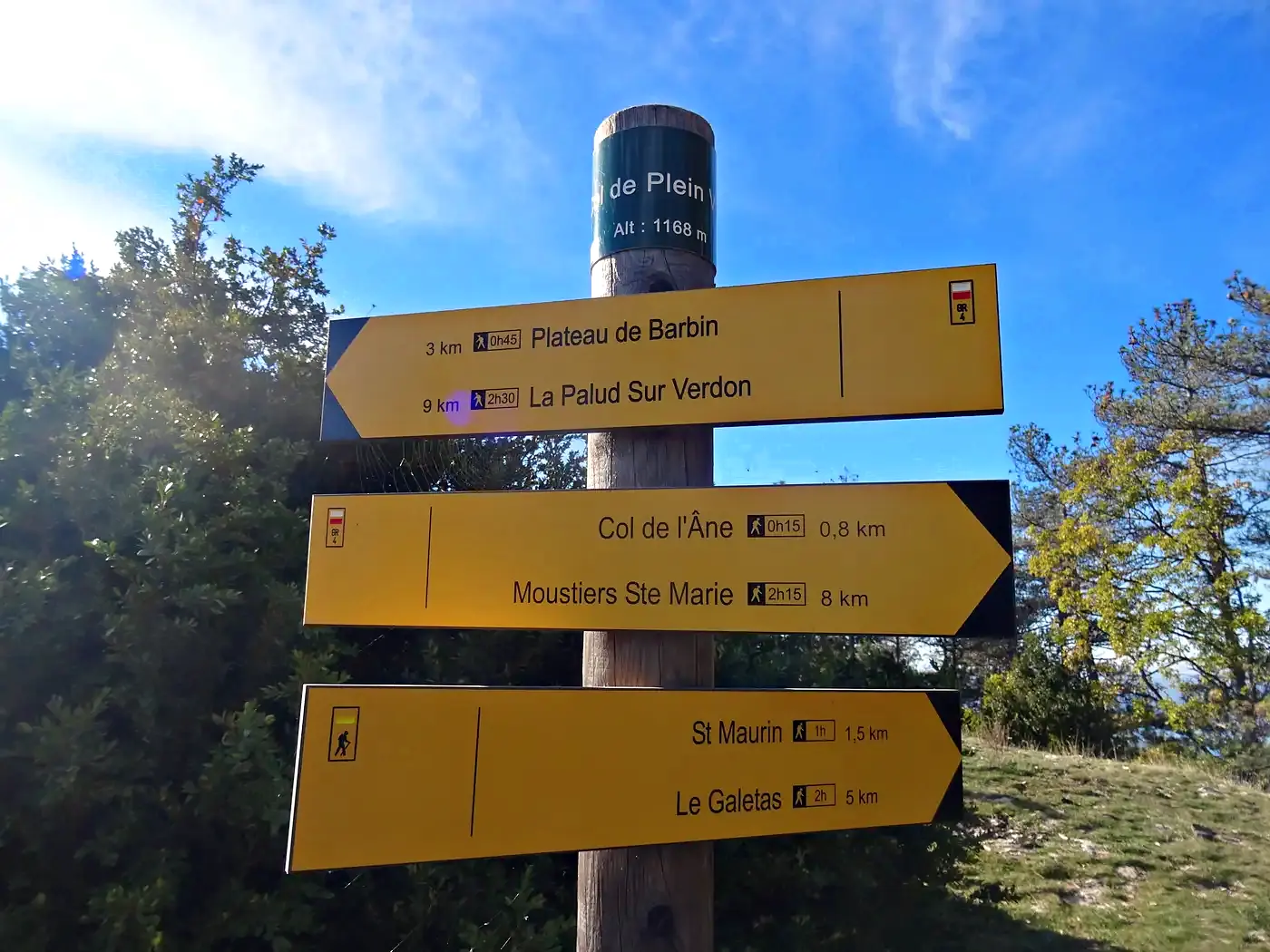
Belvédère de Plein Voir (1,168 m; summit spot height 1,194 m)
The truth about the numbers
Depending on the track recorded, distance, elevation gain and duration vary markedly from one source to another. Here are the published figures and the one we use — and why.
Data point
Value used
Other values seen
Why we settle it this way
Distance
10.49 km
9.85 (Visorando, Plein Voir variant) · 10.6 (Komoot) · 7.9 (Les Deux Petits Baroudeurs, from Félines)
The figure from the Visorando track “Très surprenants belvédères” (820 m of elevation gain, 5 h 20 min), the most complete and best documented one.
Elevation gain
820 m
756 · 700 · 620
The gaps correspond to different routes: the short variant from Félines (620 m) climbs less than the full loop (820 m).
Duration
5 h 20 min (full loop)
4 h · 4 h 32 min · 5 h
5 h 20 min for the full 10.49 km; 4 h for the short 7.9 km variant from Félines.
What you cross
The viewpoints along the Plein Voir ridges — the route’s central motif, with the plunging views over Lake Sainte-Croix and the gorges.
A natural arch, the Trou de l’Aigle, a short detour off the path after the Plein Voir viewpoints: a narrow ledge runs along the cliff to the arch, with a view of Lake Sainte-Croix and the Pont du Galetas. Several hikers’ accounts document it under this name, but it remains absent from official sources (moustiers.fr, Parc naturel régional du Verdon) and some describe it as hard to find — to be taken as a reported point, not as a fact as well established as the rest of this page.
The caves and the Saint-Maurin resurgence, passed on the way back (altituderando.com): petrifying springs that form travertines and tufa cascades, on the edge of the Saint-Maurin Regional Nature Reserve — a protected site (Parc naturel régional du Verdon, CEN PACA) whose official guided visit is made via another access, from Moustiers.
A rocky loop (Les Deux Petits Baroudeurs’ description): the ground is stony and the climb sustained. The Komoot guide ranks the southern variant of the Col de l’Âne among the region’s major challenges.
The Félines car park, the closest starting point: it is also the quickest to fill up, so plan ahead in high season.
Moustiers-Sainte-Marie at the start: a village listed among the Plus Beaux Villages de France (the “most beautiful villages in France” label), a faience town, tucked beneath its star suspended between two cliffs.
Safety
Exposed passages, without continuous equipment: the Tourisme Alpes-Haute-Provence portal advises against this loop for people prone to vertigo and reports a passage near the drop fitted with a handrail; Altituderando confirms an airy balcony path, with another exposed zone also fitted with a handrail.
On the ridge and around the Trou de l’Aigle: several hikers’ accounts report unsecured passages, and Villa O Verdon — which documents the same route — describes the descent via the Col de l’Âne as technical.
Not recommended for people prone to vertigo or for young children.
What’s still missing
We would rather say so openly: no source publishes an average rating or reviews for this route, and neither the waymarking nor the recommended direction of the loop is documented in open access. These fields will be completed as soon as a reliable source provides them.
Sources
Data first cross-checked on 5 July 2026: moustiers.fr, Tourisme Alpes-Haute-Provence portal, Altituderando, AllTrails, Visorando (tracks “Très surprenants belvédères par les cols de l’Âne et de Plein Voir” and “Belvédère de Plein Voir”), Komoot (“South of Col de l’Âne”), Les Deux Petits Baroudeurs, Verdon Nature. Rechecked and enriched on 22 August 2026 (Saint-Maurin caves and resurgence, arch known as the Trou de l’Aigle, exposed passages): Villa O Verdon, the CEN PACA (Conservatoire d’espaces naturels de Provence-Alpes-Côte d’Azur) and the Parc naturel régional du Verdon for the Saint-Maurin reserve; back to tourisme-alpes-haute-provence.com and altituderando.com, already cited, for the arch and the exposed passages. Discrepancies kept and settled above. No invented data: a missing field is flagged as such.
Frequently asked questions
Where does the Col de l'Âne and Plein Voir loop start?
Depending on the track you follow, the loop starts from Moustiers-Sainte-Marie (Visorando route page) or from the Félines car park, the closest access point — but it fills up fast.
How long does this loop take?
Allow 4 h for the short 7.9 km variant from Félines, up to 5 h 20 min for the full 10.49 km loop with 820 m of elevation gain.
Is it a difficult hike?
Yes: every source rates it difficult. It's a rocky loop of 620 to 820 m of elevation gain, which the Komoot guide lists among the region's major challenges.
What can you see from the Belvédère de Plein Voir?
Plunging views over Lake Sainte-Croix and over the entrance to the Gorges du Verdon.